Colorado's One-Of-A-Kind 'Ghost City Of The San Juans' Is A Remote, Otherworldly Spectacle In The Mountains
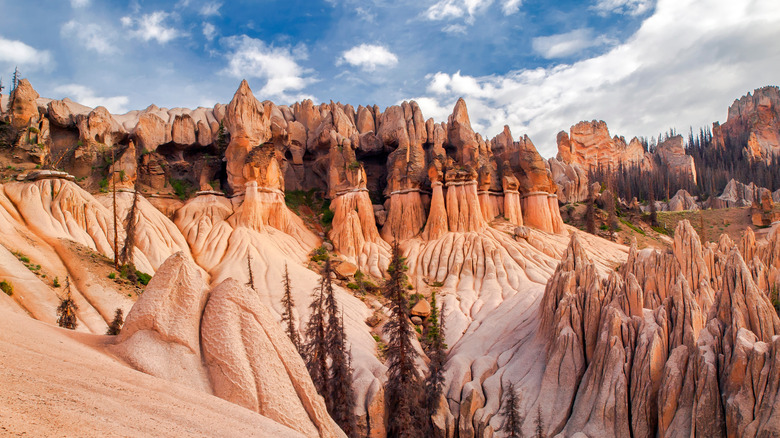
As intergalactic space travel is still the stuff of science fiction, this planet's intrepid explorers currently have to settle for otherworldly destinations here on Earth. One such place, that seems like it's been beamed in directly from a "Star Trek" episode, is the Wheeler Geologic Area in Colorado. Known as the "Ghost City of the San Juans" and sometimes called the "City of Gnomes," the deserted nature of these remote and unusual rock formations can make visitors feel like they're in a different solar system entirely.
Nestled within the Rio Grande National Forest and part of the La Garita Wilderness, the closest thing Wheeler has to nearby civilization is the old mining town of Creede, with its population just around 300. And even then, Wheeler is separated from the town by a challenging, 17.5-mile out-and-back hiking trail or an extremely bumpy, 14-mile drive in a four-wheeler. Factor in a 280-mile drive from Denver International Airport or 270-mile drive from Albuquerque International Sunport and it might feel like a lot to take on. For those who make the effort, though, this bizarre landscape of eroded volcanic ash is a worthy prize at journey's end.
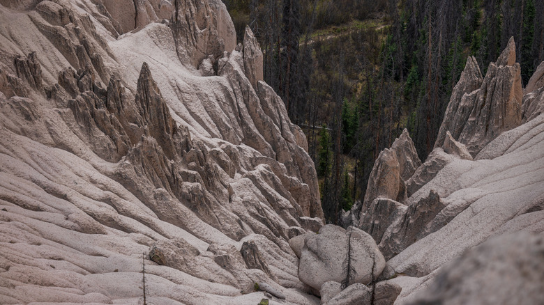
Featuring distinctive spires, pinnacles, and hoodoos, which gradually formed after a massive eruption in the southern Colorado Rockies some 25 million years ago, it was designated as the state's first national monument in 1908 by President Theodore Roosevelt, a known outdoor enthusiast. Once the second-most popular tourist attraction in Colorado, behind Pikes Peak, changing travel trends combined with the difficulty of reaching it saw Wheeler's popularity fade. With fewer people visiting today, however, that just means there's more of it for you to enjoy. Pop this geologic area on your Centennial State must-do list, alongside the spooky Gold Camp Road tunnels and surreal Hanging Lake Trail.
How to hike to the Wheeler Geologic Area
As you'll have no doubt deduced already, getting to the Wheeler Geologic Area isn't easy. But that, combined with the almost total lack of people you'll find when you finally arrive, is part of its charm. Escaping civilization and embracing solitude is what it's all about. Before grabbing your hiking boots, trekking poles, and weather-beaten backpack and marching out the door, though, keep in mind that a Wheeler Trail round trip, on average, takes just over eight hours to complete on foot and is considered a challenging route.
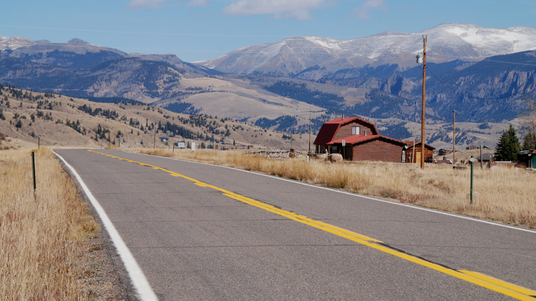
First things first, you'll need to get yourself from Creede to Hanson's Mill Campground. Do this by hopping in a car, heading southeast on Colorado Highway 149 (CO-149), and turning onto Forest Road 600 (Pool Table Road). After roughly 35 minutes of driving, along just over 16 miles of scenic roads, you'll have reached an elevation of 10,840 feet above sea level. It's here, near an old pile of sawdust – the only evidence a sawmill ever even existed in this area — and some basic camping and toilet facilities, that hikers must vacate their vehicle and set out on foot.
With a lengthy and physically demanding hike, it's important to start early and come prepared. Issues to contend with include steep sections, uneven terrain, and limited water sources. Needless to say, wear appropriate outdoor gear and carry plenty of water. Best tackled between May and October, this difficult hike rewards your efforts with gorgeous valleys and opportunities for spotting wildlife.
How to drive to the Wheeler Geologic Area
Maybe you're in the middle of a dreamy Colorado road trip itinerary and have gotten used to soaking up the state's majestic mountains from behind the steering wheel or from the comfort of the passenger seat. If so, fear not. There's a way to see the Wheeler Geologic Area using petrol power. Just don't, whatever you do, expect a comfortable ride.
Once you've reached Hanson's Mill, following the same roads from Creede that hikers initially take, the four-wheel drive route will be well signposted. Rather than forking off onto the walking route known as Wheeler Trail, also called East Bellows Trail, continue on for almost 14 miles in one direction to reach the geological marvel. Along the way, you might see other off-road vehicles heading to or back from Wheeler. Don't be alarmed by the nature of what you're driving on. A narrow dirt road, cutting between ravines and serving up deep ruts and sizable rocks as obstacles, is par for the course. Even in a vehicle designed to tackle this type of terrain, going will be slow, and the drive in alone can take between three and four hours. Be warned: Conditions can suddenly get worse, and the route is naturally more complicated during or just after rainfall and snowstorms.
For updates on the roads prior to your drive, visit the Divide Range District office in Creede (only open during the summer). Do keep in mind that the route finishes roughly half a mile from the formations, so there will be some walking involved. Outdoor enthusiasts should stay at one of the Rio Grande National Forest's 33 campgrounds. Tired of adventuring? Relax at the charming Creede Hotel and Restaurant. This National Historical Property is the town's oldest lodging and dining establishment.