A Majestic Mountain State Park Near San Francisco Has Misty Redwood Trails, Camping, And Ocean Vistas
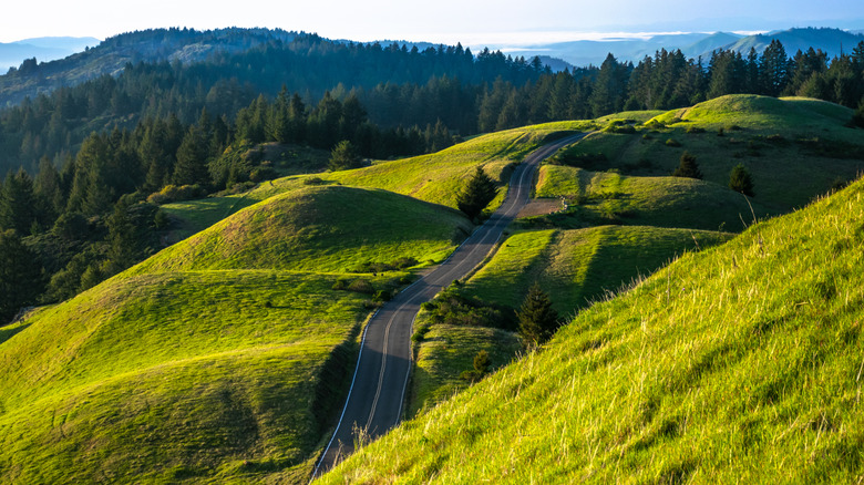
San Francisco might have made a name for itself as an international tech powerhouse, but those who have lived in the Bay Area will know that its real appeal lies in the majestic mountains, ocean vistas, and misty redwood forests that surround the city. Just north of the Golden Gate Bridge, Mount Tamalpais — or Mount Tam, as locals call it — peaks at 2,571 feet. Those who reach its summit are rewarded with sweeping views across the Marin County Hills, San Francisco skyline, and, on a clear day, the distant Farallon Islands, a wildlife refuge home to a colony of seabirds. Mount Tamalpais, open year-round from 7 a.m. to sunset, includes 60 miles of hiking trails that connect with a system of more than 200 miles of trails in neighboring parks. The state park, home to coyotes, deer, and even mountain lions, features different landscapes and terrains that change just as quickly as the Bay Area's weather.
In 1928, a conservation-minded couple from Marin County donated 200 acres of land to create what would become Mount Tamalpais State Park. With the help of the Tamalpais Conservation Club, the park now spans over 6,300 acres and welcomes more than 800,000 visitors each year, making it one of the region's most beloved spots for hiking and camping. Outdoor activities are an essential part of San Francisco's culture, so much so that it is often ranked among the best lifestyle-focused cities in America.
The state park borders the Golden Gate National Recreation Area, along with land managed by the Marin Municipal Water District. Within the Golden Gate National Recreation Area, you'll find the Muir Woods National Monument, home to the world's tallest tree species, and Stinson Beach, one of Northern California's best-kept coastal secrets.
Hike the mountain trails at Mount Tamalpais State Park
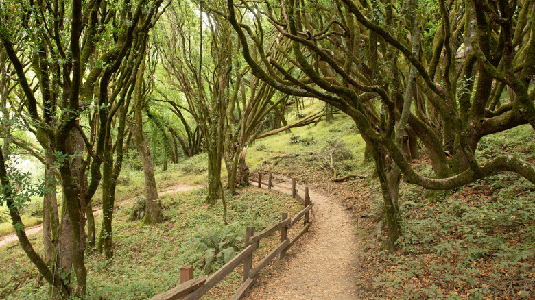
The Dipsea Trail, Steep Ravine, and Matt Davis Trail form a stunning 7-mile loop through the state park — one which you can tweak with a few variations. The trail circles between Stinson Beach and the Pantoll Ranger Station, with starting points at either end. If you start at Stinson Beach, which has three public parking lots, you can head uphill via the Steep Ravine, winding through a lush redwood forest and passing two waterfalls along Webb Creek. Once you reach Pantoll Ranger Station, cross the road and descend back down to Stinson Beach on the Matt Davis Trail.
Another great hike is the Bootjack Trail to Muir Woods National Monument. Starting either inside Muir Woods or at the Bootjack Trailhead, this 6.5-mile loop is a moderately challenging hike that will take you deep into the heart of the misty redwoods. Keep in mind that Muir Woods charges a $15 fee if you're entering from within the monument itself.
One of the most attractive features of Mount Tamalpais is that you don't need to hike miles to experience sensational ocean vistas. A third hike, known as East Peak Plank Walk Trail, offers some of the best views of the Bay Area. It is less than a mile walk to the summit from the East Peak parking lot. On the summit you will find the Garner Fire Lookout Tower. Built in 1935 to monitor wildfires in Marin County, this rugged tower is still an active fire department lookout. Mount Tamalpais is often considered one of the best places to see wildflowers in California. Come spring, the open grasslands burst into color with calla lilies and California poppies, along with another 750 plant species.
Everything you need to know about camping at Mount Tamalpais State Park
For those who want to extend the experience, the park offers a variety of campsites. The two most popular are located at the Pantoll Campground and the Bootjack Campground just off the Panoramic Highway. Each has 15 campsites that operate on a first-come, first-served basis. While the campsites have no entrance fee, the parking lots at both Pantoll and Bootjack charge a parking fee of $8 per night. These campsites can accommodate a maximum of six people each and are equipped with picnic tables, toilets, and potable water.
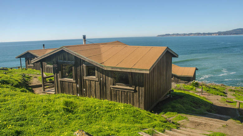
The Steep Ravine Environmental Campground, which is located around a mile south of Stinson Beach, features nine basic cabins, each with a wood stove and sleeping platforms. Reservations are required for the cabins, which were built in 1938, as well as seven walk-in campsites nearby. The campground charges $100 per night per cabin plus an $8 booking fee, which covers five guests. The walk-in campsite also requires a $25 booking fee to reserve a spot. For larger groups, the Alice Eastwood Group Camp offers two camping areas that can accommodate groups of 25 to 50 guests, with tables, grills, potable water, and toilets.
The park is less than a 45-minute drive from San Francisco, depending on traffic. Driving is the easiest and most flexible way to get there. However, the park is also reachable by public transport. From Mission and 5th Street, catch the 150 or 130 bus (on Golden Gate Transit) towards San Rafael. Once across the Golden Gate Bridge, the bus will stop at the Marin City Hub. From there, hop on the West Marin Stagecoach bus 61 towards Bolinas, which will take you right to the Pantoll Campground parking lot.