A Historic River In Ohio Reveals Islands, Serene Trails, And A Rich Tapestry Of Natural Wonders

Running for 137 miles from the underrated but highly affordable Fort Wayne, Indiana, to its confluence with Lake Erie in Toledo, Ohio, the Maumee River is a historic waterway that weaves a rich tapestry of natural wonders through the Buckeye State. It was designated a State Scenic River in July 1974, and continues to draw locals and travelers alike with its beauty. With the main body of the river flowing through five Ohio counties, the Maumee is incredibly easy to access. Several of the most iconic points along the river, including spots in Waterville, Grand Rapids, and Defiance, are 20 minutes to an hour's drive from downtown Toledo.
The Maumee River itself has played a key role in the development of northwestern Ohio. Originally the stomping ground of the native Miami Tribe, European settlers sought to establish farmland in the area by draining the vast Great Black Swamp the Maumee flowed through at that time. These rich agricultural lands exist to this day, and the Maumee River watershed extends over 5,000 square miles across 17 Ohio counties and into Indiana and Michigan. While the river has been subjected to several decades worth of pollution, the present state of the Maumee is one of restoration and conservation; work is being done for present and future generations to enjoy all of the wonderful outdoor recreation this iconic waterway has to offer.
Explore the islands of the Maumee River
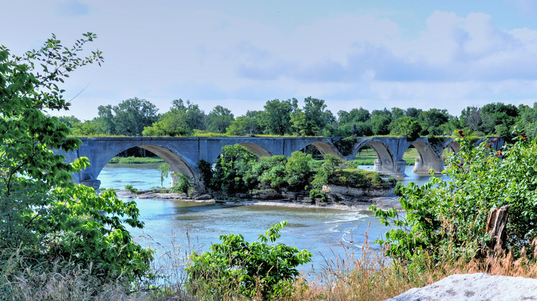
Ohio's most famous island might be Kelleys Island, a wonderful, under-the-radar island for all seasons, but the Maumee River also boasts its fair share of beautiful, accessible islands. The Maumee River starts its northeasterly journey along the mainly flat, shallow lands of western Ohio, eventually opening up into a far deeper, more rapidly flowing water that confluences with Lake Erie outside of Toledo. It's in this deeper section of the river that many of Maumee's scenic islands are revealed.
Some of these islands, such as the 9-acre Howard Island at Grand Rapids, are closed to the public except through guided tours from the Black Swamp Conservancy. Others, including the Missionary Island Wildlife Area in Waterville, are open to the public. Missionary Island is several hundred acres of pristine wetlands, marshes, and forests that create a diverse habitat for an array of wildlife. Song and shorebirds find excellent homes here (making the island a haven for birders), trails lead hikers around the island, and the abundance of fish in the river (especially walleye) is prized by any angler. Islands abound in the Toledo section of the river as well. As of 2024, a $13 million revitalization project by the Toledo-Lucas County Port Authority is working to rejuvenate Walbridge Park's popular Clark, Delaware, and Horseshoe Islands. Long a major spot for boating and walking, the project aims to make the islands more accessible for sport while aiding the revitalization of river habitats.
Experience the Maumee River Water Trail
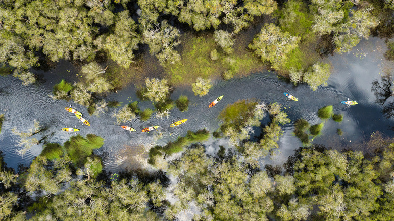
Ohio has no shortage of charming riverside towns like Portsmouth, but the best way to experience the Maumee River is on the water itself, not from the shores. The Maumee River Water Trail is a 107-mile long stretch of river connecting greater Toledo's metroparks with state parks, wildlife areas, and several other natural locations along the Maumee.
The Water Trail is a wholly unique way to experience this iconic body of water, with 39 access points where you can bring your kayak or canoe to begin your journey along this great river. With numerous spots to camp along the river, including Mary Jane Thurston State Park in Grand Rapids and Granger Island in Waterville, it makes for a great multi-day paddling adventure; depending on your level of paddling experience, you can take up to four days to explore this scenic trail. Paddlers should be aware of two portages: One is just past the Gilead Side-Cut Canal in Grand Rapids, the other is at the Independence Dam outside of Defiance. Moving along the river takes you to some truly scenic areas; as the lowlands and farms of the flat western section give way to the wider rapids of the eastern portion — and eventually pour out into the wide maw of Maumee Bay in Lake Erie — you can appreciate why this river has been so popular and necessary to this beautiful corner of Ohio.