A Spectacular Trail Hidden In California's Sierra Nevada Leads To A Smaller, Secret Version Of Yosemite Valley
Few sights in America's National Park System are more iconic than the breathtaking view of Yosemite Valley in California's Yosemite National Park. With its vast gorge barricaded by titanic rocky monoliths like El Capitan, Yosemite Valley has inspired awe and wonder among human visitors long before the National Park Service existed. Add Yosemite's soul-satisfying hikes up icons like Half Dome, and you get one of the most-visited national parks in the U.S. Despite Yosemite's prestige, large visitation numbers also mean huge crowds and annoying traffic, side-effects that can cause some people to seek out alternative outdoor destinations. Fortunately, California's lesser-known High Sierra Trail offers a secret yet spectacular analog of Yosemite Valley.
Like the trails of Yosemite National Park, the High Sierra Trail covers a magnificent stretch of California's mighty Sierra Nevada Mountains. At more than 70 miles long, and with over 16,000 feet of elevation gain, the High Sierra Trail is not for the faint of heart. Most hikers will need multiple days to complete the entire route and will likely need sufficient levels of physical fitness, mountaineering experience, and proper gear. For those up to the challenge, the High Sierra Trail is arguably the best way to experience the heavenly beauty of California's High Sierras, beginning at one of the nation's oldest and most beautiful national parks and ending at the highest point in the contiguous U.S.
The High Sierra Trail is a challenging yet rewarding trek through California's Sierra Nevada
The High Sierra Trail's most common route begins at the Crescent Meadow area of Sequoia National Park. Though not quite as famous as Yosemite, Sequoia is America's second-oldest national park and an awe-inspiring California gem defined by its namesake giant trees. With almighty forests and high-elevation Sierra Nevada peaks, Sequoia National Park is already a great Yosemite alternative. And this is just the start of the High Sierra Trail. Hikers beginning at Crescent Meadows will likely arrive from Fresno, the nearest major city. If you're flying in from elsewhere in the country, Sequoia is about a four- to five-hour drive from major airports like LAX and San Francisco International. Of course, if you're hiking the High Sierra Trail, remoteness from civilization is probably a selling point.
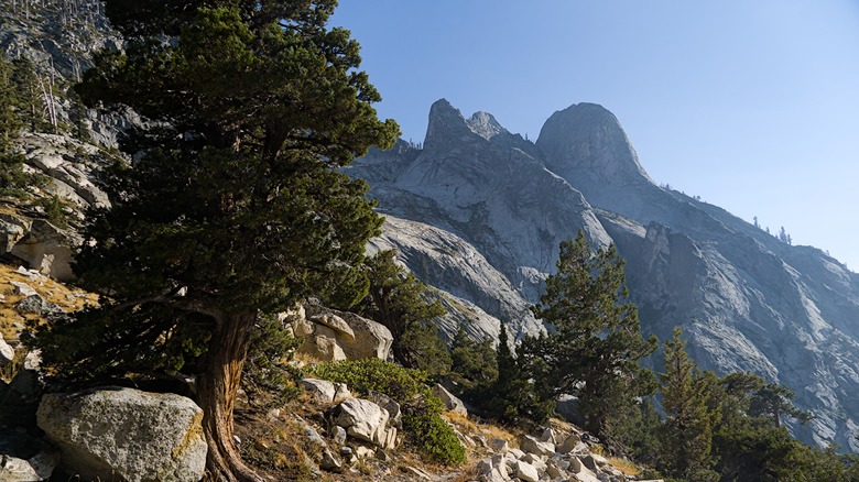
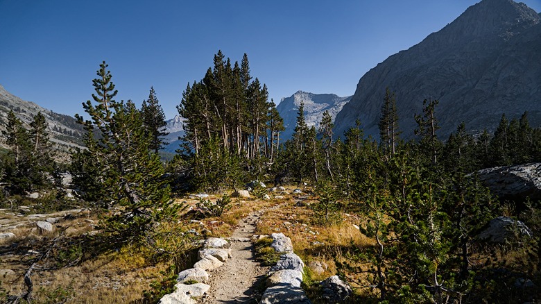
The Crescent Meadow Picnic Area could not be a better starting point for the High Sierra Trail, as you'll witness a peaceful mountain clearing with groves of mighty giant sequoia trees towering above. Continue on the route to reach the astonishing Moro Rock, a 6,725-foot granite monolith that evokes obvious comparisons to Half Dome. Even if you only stick to the first few miles of the High Sierra Trail, you'll still get an amazing replica of Yosemite National Park. If you continue, the next several dozen miles will showcase abundant High Sierra forests, mountain lakes, waterfalls, meadows, creeks, and other highlights of Sequoia National Park until the trail merges with the more popular John Muir Trail at the junction near Wallace Creek. Over the next 13 miles, the High Sierra Trail begins to leave Sequoia National Park and enter some of the most dramatic sights in the Sierra Nevada.
The High Sierra Trail culminates at the highest point in the lower 48 states
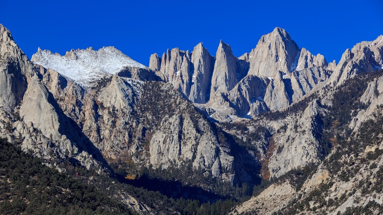
Eventually, you'll enjoy a downhill section as the trail descends the scenic Kern River Canyon. But this is more of a palate cleanser, as the trail's grand finale involves one of the nation's most epic uphill climbs. From the Wallace Creek Junction, the trail enters the Whitney Portal, where Sequoia National Park borders the Inyo National Forest. Here, you'll likely notice the trail's breathtaking climax, the majestic Mount Whitney. At 14,505 feet, Mount Whitney is not only the highest mountain in the Sierra Nevada and California — it's also the highest mountain in the contiguous American states.
Despite its record altitude, Mount Whitney is less than 100 miles away from the lowest point in North America at Death Valley's Badwater Basin. This geographic quirk lets you see both the highest and lowest points in the contiguous U.S. from points like the nearby Telescope Peak. Of course, successfully summiting Mount Whitney is no easy feat. In addition to the steep climbs and difficult terrain, altitude sickness is a potential hazard. Proper gear and physical conditioning are essential. Also, note that the High Sierra Route to the summit takes a bit longer than the more popular route from Inyo National Forest.
Access to much of the High Sierra Trail, including the Mount Whitney summit, requires a $15 wilderness permit from May to September. While peak hiking season is in the summer, June and September are great months to go if you don't mind high water levels in the creeks and some snow. During winter, make sure to look out for any trail or road closures. Hotels are few and far between, so your sleeping options on the High Sierra Trail will be limited to the trail's many camping sites.