This Bucket List Volcano Hike In Washington Is Just As Dangerous As It Is Breathtaking
If you'd been standing on the steps of the public library in downtown Portland, Oregon on the morning of May 18, 1980, you would have felt a rumble and looked up to see a giant mushroom cloud of smoke and ash erupting in the sky to the northeast. Nuclear armageddon would have flashed through your mind as you stood rooted to the ground, but, eventually, you'd learn the culprit wasn't the Cold War, but an erupting Mount St. Helens, one of the imposing stratovolcanoes that make up the Pacific Northwest's mighty Cascade Range.
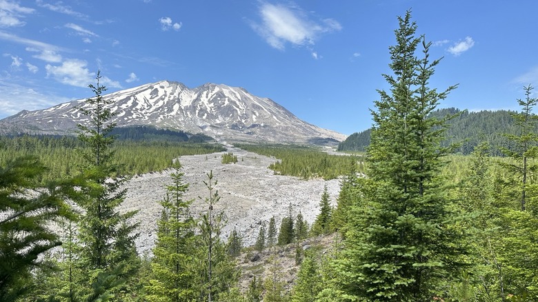
Today, when viewed from any number of scenic viewpoints to the south, Mount St. Helens, located in Washington, less than two hours from Portland, still looks like a soaring, symmetrical peak, its glaciated slopes rising to a pristine summit. But looks can be deceiving.
The summer season's hike to the top is not at all technical, and you will need a permit, but unlike the hike up Europe's tallest active volcano, Mt. Etna, you aren't required to have a guide. That said, this endeavor is unbelievably grueling, as you pick your way across a seemingly endless boulder field, then trudge another mile up a steep slope of slippery volcanic ash to the top. Once you arrive there, the big reveal is breathtaking, not just because it's beautiful, but because you suddenly realize that the mountainside that appeared to be so solid as you climbed up it is just a shell, and the north side of the mountain is just, well, missing. You're staring down into a gaping crater, all that's left after that massive eruption in 1980, which killed 57 people as it blew 1,300 feet off the top of a once-solid mountain. And, even though it's open to visitors, it's still a dangerous place to be.
Climbing Mount Saint Helens
Starting at the drive-up camping area known as Climbers' Bivouac and taking the Monitor Ridge Route, you'll climb 4,500 feet over five miles. That's the same amount of elevation gain and loss you'd log backpacking in and out of the Grand Canyon on the similarly dangerous Bright Angel Trail. Here, though, you're at a much higher elevation, reaching over 8,000 feet at the summit, and doing it all in one day rather than two. Be careful — hikers here frequently get lost and need to be extracted by the local Volcano Rescue Team.
The first couple of miles are a pretty ramble through gradually thinning forest. Eventually, above the tree line, you'll reach the boulder field. This is where AllTrails reviewers begin to use words like "brutal," "endless," and "dreadful" to describe the hike, and you will, too. Picking your way through the boulders involves a lot of strategic calculation. The trail here is just a series of marker poles indicating a general direction; where you put your feet and hands is up to you.
The boulder field will seem like a picnic once you set foot on the slippery ash slope leading to the summit. You've got 1,000 feet of elevation to climb in the last mile, but it can seem double that because you slide backward with every step. Some climbers say hiking over snow is easier than contending with the slippery ash and recommend going in June, when summer conditions have already arrived, but the snow fields are still intact, making for a more sure-footed surface under crampons. Either way, eventually you'll reach the top.
Mount Saint Helens' summit
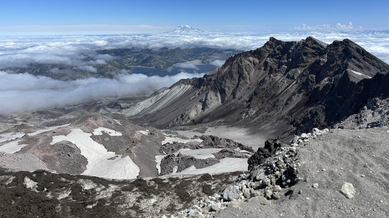
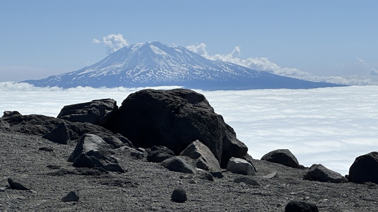
Once you get there, be sure to take a moment to appreciate the 360-degree views of majestic Mount Rainier, as well as Mount Adams and Mount Hood, all of which you can see looming in the distance on a clear day, or maybe even jutting out of a layer of clouds stretching out below you. The crater below is 2,000 feet deep and two miles wide. You're looking at an ever-changing lava dome that occasionally emits a puff of steam, and beside it, the world's youngest glacier.
Early in the season, the summit rim may still be covered in a snow "cornice," an overhang that can break underneath you if you walk on it. As recently as 2024, an experienced climber with 28 trips to the summit under his belt fell 1000 feet to his death when the cornice he was standing on collapsed. Even after the snow has melted away, the summit rim is highly unstable, so you should stay well back from it.
The summit isn't where you're most likely to get into trouble, however. Many hikers look forward to glissading down the mountain's permanent snow fields on the return trip. Glissading is a mountaineering technique where you sit down and use the snow or ice as a giant slide, using an ice axe to self-arrest at the bottom. Most injuries on the mountain happen while hikers are doing this, and whooshing down a mountain at high speed isn't the greatest time to realize you forgot to pack your ice axe.