Explore California's Striking Coast On This Beach And City-Filled Road Trip
If you're looking for one of the best road trips in California, arguably in the U.S. and even the world, make a beeline for California's Highway 1. It runs primarily along the coast for 656 miles from Dana Point in Orange County all the way north to Leggett in Mendocino County. Along the way, you get some of the state's most incredible ocean views, and it also snakes through some of California's most iconic cities, from Los Angeles to San Francisco.
The road is a (largely) two-lane highway, running along the top of bluffs and cliffs near the water's edge, giving roadtrippers breathtaking views of the Pacific Ocean and easy access to some of the state's best beaches. The twists and turns of the highway through the more remote stretches force you to slow down, which means safer driving and better chances to admire the landscape. While a determined driver could drive the entire thing in a day without stopping — barring any closures in the Big Sur area (more on that later) — Highway 1 is designed to help you take your time and enjoy your surroundings. Give yourself several days, if possible, to get a feel for the varied communities and landscapes along the journey. Alternatively, you can split it into parts and do each section over a long weekend. Whichever way you choose to drive Highway 1, we're sure you're going to love it.
Dana Point to Santa Monica
Heading north out of Dana Point along Highway 1, you don't have to go far to find some of the best beaches in Southern California. 1000 Steps Beach between Dana Point and Laguna Beach is a less crowded, more tucked-away beach stop. Despite the name, it's only a few hundred steps to the water, and you'll be rewarded for your efforts with access to one of the area's most famous sea caves. Elsewhere, after some challenges in the early 2000s from Santa Cruz to the north, Huntington Beach is officially "Surf City USA." The Huntington Beach International Surfing Museum will tell you more about the area's surf culture, including the debate over the name. Try your hand (or feet, technically) at surfing yourself, or enjoy watching surfers from the pier.
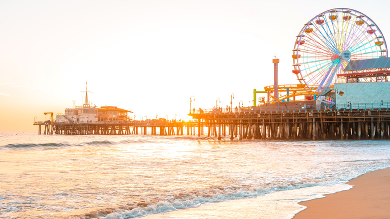
Continuing north, you'll find Venice Beach Boardwalk with its street performers, bodybuilders, and free spirits — every weekend, there's a drum circle around sunset. Next comes Santa Monica Beach and its famous Santa Monica Pier, where you can play carnival games and ride rides, including its much-photographed Ferris wheel. If you want to head into Los Angeles during your Highway 1 road trip, maybe even take a picture with the iconic Hollywood sign, now's the time. If you're spending the night in Santa Monica, the Shore Hotel is a popular, eco-friendly boutique hotel right next to the pier, which has beach cruiser bikes available, as well as surfboard rental and lesson packages.
Santa Monica to San Luis Obispo
Continuing north along the coast out of Santa Monica will take you towards Malibu. If you're a fan of history and art, stop by the free Getty Villa, modeled after a first-century Roman summer house. As you pass Malibu, the Pacific Ocean sprawls on your left, and the Santa Monica Mountains spread on the right. At one point, the highway cuts through the massive formation called Mugu Rock at Point Mugu State Park. The park is worth exploring, whether just the beach or the 70 miles of trails.
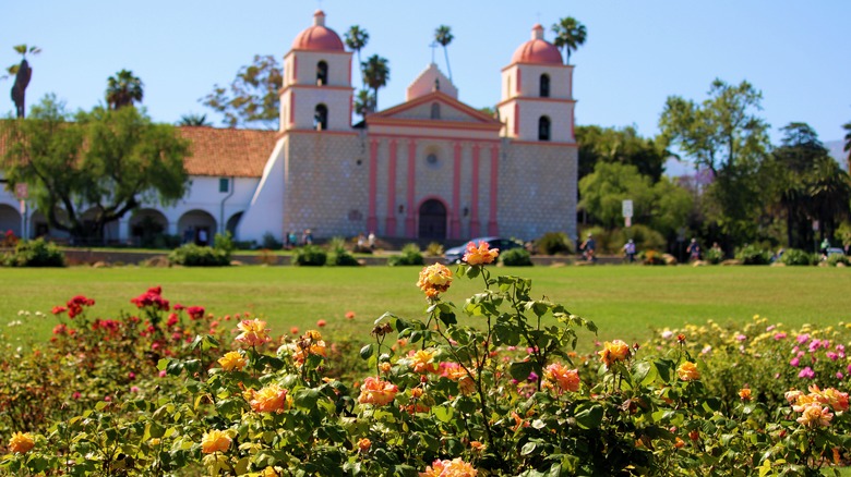
It's just under 60 miles from Mugu Rock through Oxnard up to Santa Barbara and its amazing beaches, an area aptly known as the American Riviera because of its Spanish Colonial Revival architecture and mild climate. While you're there, learn a bit about California's (undeniably complicated) history of missions at Old Mission Santa Barbara, with its distinctive twin bell towers.
The highway then moves inland for about 100 miles and drops back down to the ocean near Pismo Beach. In winter, you can see the migrating monarch butterflies at Pismo State Beach. Another hour of driving takes you to San Luis Obispo, a laidback college town with a legendary year-round farmers market. If you're spending the night here, consider staying at Madonna Inn. First opened in 1958, it's now a landmark destination where each room has a unique, quirky theme, with names like "Jungle Rock" and "Caveman."
San Luis Obispo to Carmel
The next city on the route is Morro Bay, home of the 576-foot Morro Rock, a navigational aid for sailors. Walking along the nearby Embarcadero, you're likely to spot sea otters — what a way to start your day! San Simeon is another 30 minutes north, where you can find the Piedras Blancas rookery (where thousands of northern elephant seals come ashore) and the incredible Hearst Castle.
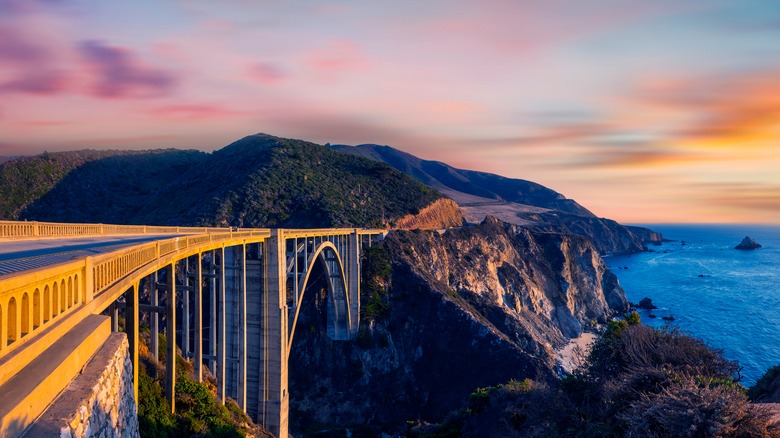
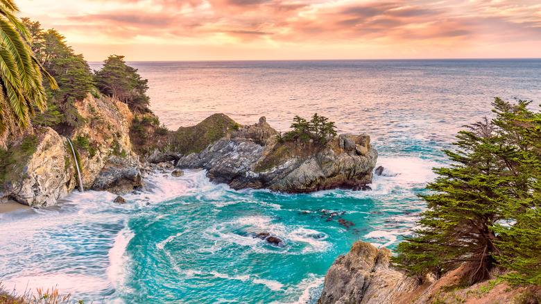
North of San Simeon is Big Sur, arguably the most legendary section of Highway 1. The highway winds through redwood forests and towering bluffs as the waves crash dramatically below. Break up the drive with stops at Julia Pfeiffer Burns State Park with the majestic McWay Falls — an 80-foot-tall waterfall flowing onto the beach — and Andrew Molera State Park, with miles of trails and sandy beaches. While Big Sur has no shortage of dramatic natural landscapes, its most impressive artificial feature is Bixby Bridge, featured in many car commercials. Highway 1 is sometimes closed through Big Sur because of landslides, and to continue north, you may have to go inland to the 101. Be flexible with your plans, particularly during winter.
The natural beauty doesn't stop at Big Sur. On the way to often-overlooked Carmel is Point Lobos State Natural Reserve, which painter Francis McComas called "the greatest meeting of land and water in the world," according to California State Parks. Stay the night in Carmel; the Stilwell Hotel is a comfortable boutique hotel with free parking and breakfast.
Carmel to Tomales Bay
Up the road from Carmel is Monterey, where the world-renowned Monterey Bay Aquarium offers a deeper insight into the marine ecosystems under the nearby seas. As you travel north, the landscape changes with farm fields on either side of the road growing artichokes, strawberries, and more — stop by a farmstand on the way for some fresh produce. In the heart of Monterey Bay, Elkhorn Slough is an ideal spot for kayaking, paddleboarding, and spotting wildlife like sea otters, harbor seals, and even whales. At the north end of Monterey Bay is the beach town of Santa Cruz, a vibrant city with one of the world's best seaside parks. Santa Cruz is also a renowned destination for surfing.
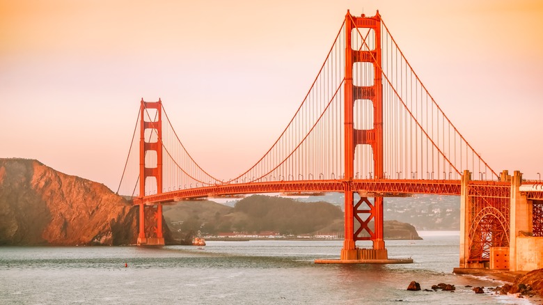
From Santa Cruz to San Francisco, it's around 80 miles of beautiful coastline without the turns of Big Sur or those farther north. State beaches dot the route along the coast, and one of the few major towns on the way is Half Moon Bay, a charming little beach city with miles of sand. Highway 1 takes you into the heart of San Francisco, through Golden Gate Park and across the Golden Gate Bridge. It then winds through the Tamalpais Valley down to Muir Beach, near the famous Muir Woods National Monument, before tracking along Olema Creek towards Tomales Bay. For a historic night's stay, the Lodge at Marconi near Marshall was the base of a 1970s cult before reopening in 2023 as a completely remodeled, upscale 45-room retreat.
Tomales Bay to Leggett
The winding northern portion of Highway 1 is less traveled than its southern counterpart, but the ocean views are no less spectacular. If you have the time for a couple more nights, it's worth lingering to embrace the region's remote, rugged allure. North of historic Fort Ross is Timber Cove Resort, where guests can watch the sunset over the ocean without leaving the bed. It's also the location of California's second smallest state park — the 60-foot circular park surrounds Benjamin Bufano's Peace Obelisk, a 93-foot sculpture above the beach. Farther north is Elk Cove Inn & Spa, which has a private set of stairs to a secluded beach. Many of their 16 rooms have large soaking tubs and fireplaces, ideal after a long day of driving.
Jug Handle State Natural Reserve has a large, bluff-bordered beach plus a unique "Ecological Staircase" hike that leads to a pygmy forest. Big River Beach near Mendocino is a large, protected, white sand beach near an estuary, which means lots of wildlife. There aren't as many large cities in this section; the largest town on the Mendocino County coast is Fort Bragg, where you can search for sea glass at the beautifully unique Glass Beach near MacKerricher State Park. It is around 45 miles from Fort Bragg to Leggett, the small town where Highway 1 meets 101. It's also the site of the Chandelier Drive-Thru Tree, a 315-foot-tall coastal redwood that you can — believe it or not — drive through.